Saarburg
This article needs additional citations for verification. (June 2023) |
Saarburg | |
|---|---|
 | |
Location of Saarburg within Trier-Saarburg district  | |
| Coordinates: 49°37′N 6°33′E / 49.617°N 6.550°E | |
| Country | Germany |
| State | Rhineland-Palatinate |
| District | Trier-Saarburg |
| Municipal assoc. | Saarburg-Kell |
| Subdivisions | 4 |
| Government | |
| • Mayor (2019–24) | Jürgen Dixius[1] (CDU) |
| Area | |
• Total | 20.63 km2 (7.97 sq mi) |
| Elevation | 159 m (522 ft) |
| Population (2022-12-31)[2] | |
• Total | 7,597 |
| • Density | 370/km2 (950/sq mi) |
| Time zone | UTC+01:00 (CET) |
| • Summer (DST) | UTC+02:00 (CEST) |
| Postal codes | 54439 |
| Dialling codes | 06581 |
| Vehicle registration | TR, SAB |
| Website | saarburg.de |
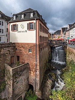
Saarburg (German pronunciation: [ˈzaːɐ̯bʊʁk], [ˈzaːɐ̯bʊʁç]) is a city of the Trier-Saarburg district, in the state of Rhineland-Palatinate, Germany, on the banks of the river Saar in the hilly country a few kilometers upstream from the Saar's junction with the Moselle. Now known as a tourist attraction, the river Leuk flows into the town centre and makes a spectacular drop of some 60 feet before joining the larger Saar that bisects the town. The waterfall is the result of a 13th-century project to redirect the Leuk through the city centre.
Saarburg is the seat of the Verbandsgemeinde ("collective municipality") Saarburg-Kell. The area around Saarburg is noted for the cultivation of Riesling grapes.
History
[edit]
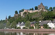
The history of the city begins with the construction of the now-ruined castle by Graf Siegfried of Luxembourg in 964. It received its town charter in 1291. The city has a bell foundry, the Glockengießerei Mabilion, which has been in operation since the 1770s, and as of 2003[update] the only one in Germany that produces bronze bells.
From 1945 to 1948 Saarburg was occupied by troops from Luxembourg. From 18 July 1946 to 6 June 1947 Onsdorf, in its then municipal boundary, formed part of the Saar Protectorate. French troops complemented the occupation until 1955.
Saarburg has a proud history with bells, being the producers of bells for many German cathedrals.
Gallery
[edit]-
Saarburg, castle, Ober- und Unterstadt
-
Catholic church (Pfarrkirche Sankt Laurentius)
-
Reformed church and the river Saar
-
Stained glass by Werner Persy in the Protestant Church Saarburg
Twin towns — sister cities
[edit]Saarburg is twinned with:
 Sarrebourg, France (1952)
 Soulac-sur-Mer, France (1972)
Born in Saarburg
[edit]- Marianne Baum (1912–1942), resistance fighter against Nazism
- Alexander von Warsberg (1836–1889), Austrian government official and travel writer
References
[edit]- ^ Direktwahlen 2019, Landkreis Trier-Saarburg, Landeswahlleiter Rheinland-Pfalz, accessed 2 August 2021.
- ^ "Bevölkerungsstand 2022, Kreise, Gemeinden, Verbandsgemeinden" (PDF) (in German). Statistisches Landesamt Rheinland-Pfalz. 2023.
External links
[edit]


